Spiralweb Stewardship Association · Applied Field Learning
Land, Water and Living Stewardship
A place-based framework for regenerative inquiry and action
← Spiralweb PapersApplied Field LearningProtocol HabitatPG Ledger ↗Download PDF
Questions may travel. Answers and authority do not.
Contents
- Executive summary
- Purpose and scope
- Core definitions
- Land and water as one field
- The knowledge architecture
- The common field inquiry
- Three readings that do not compensate
- Practice families and their limits
- What the external evidence supports
- Current field pixels
- From pixels to bioregional learning
- The PG Ledger and Flow Desk
- The role of AI and the workbench
- Minimum responsible baseline
- Research agenda
- Conclusion
- Source and evidence map
Executive summary
Spiralweb works with places that differ in climate, history, tenure, water, knowledge, livelihood and institutional setting. The common task is therefore not to distribute one regenerative model. It is to support a disciplined way of finding out what a place can carry, what its stewards want to protect or change, and what the consequences of a next step actually are.
Land and water are treated here as one living field. Water availability cannot be read apart from soil cover, vegetation, geology, extraction, pollution, labour, rights and public infrastructure. A greener field is not necessarily a more water-secure field. A technically efficient intervention can still increase total demand, shift harm elsewhere or become impossible to maintain. Conversely, a modest act of protection, repair or assisted natural regeneration may be more consequential than a visible planting programme.
The proposed Spiralweb contribution is a place-held learning architecture. It connects local observation, scientific and technical knowledge, institutional memory, resource flows and public learning without giving any one source automatic sovereignty. The field can correct the record. The steward can refuse. Unknown remains a valid state. Money does not buy tempo, authority or a favourable narrative.
| THE SHARED QUESTION How can locally held stewardship strengthen a place’s capacity to receive, hold, clean, circulate and share water while stewards remain viable and total use stays within hydrological and ecological limits? |
|---|
The paper advances six working propositions.
No single practice family is regenerative by definition. Agroforestry, food forests, syntropic systems, water harvesting, irrigation, grazing management, wells and restoration can each help, fail or displace harm depending on place and design.
The strongest transferable unit is not a technique but an inquiry grammar: listen, bound the question, build a proportional baseline, compare options, make the smallest responsible movement, observe consequences, return and correct.
Ecological improvement cannot compensate for exhausted stewards or illegitimate governance. Spiralweb therefore keeps Land and Life, Steward Viability, and Governance and Commons as separate readings.
Scientific evidence should inform local judgment without pretending that results from one climate, land use or social setting transfer intact to another. Local knowledge is indispensable and also fallible. Both require provenance, dialogue and correction.
A PG Ledger becomes real only when dated observations, decisions, resource flows and Returns alter later action. Until that cadence exists, Spiralweb has proposals, baselines and early formats rather than a validated operating system.
The present field relationships are at different stages. Doukkala and Firmaty are living relationships with preparatory field inquiries. Kitgum has an early locally authored readiness record and one Dashboard reading, not a regular Ledger cadence. Xochimilco is a mature social-ecological field in which Spiralweb may support a bounded relationship, not introduce regeneration to an empty place.
One grammar, several names
| Earlier or Danish wording | Wording in this paper | Function |
|---|---|---|
| Stream A | Land and Life | Ecological condition and consequence. |
| Stream B | Steward Viability | Whether the people carrying the work can continue without hidden depletion. |
| Stream C | Governance and Commons | Authority, consent, decision, shared memory and correction. |
| The second ledger | Affected-field and catchment standing | Effects displaced beyond the local boundary: aquifer, downstream users, coast, future users and other life. |
| Financial Ledger | Resource-flow memory | How money, materials, labour and time moved, for what purpose, and what followed. |
| Flow Desk | Relational operating surface | Receives signals, routes attention, protects boundaries and returns decisions. |
| PG Ledger | Connected, correctable whole | The above becomes a Ledger only through continuity, Return and later correction. |
| AI WORKBENCH BOUNDARY AI may support attention and memory. It does not confer local authority or consent; consequential claims retain a checkable human and source route; sensitive knowledge is minimised; synthesis is labelled; and no funding, stoplight or activation decision is automated. |
|---|
Purpose and scope
This paper provides a common professional frame for Spiralweb’s work where land, water, food, habitat and human livelihood meet. It is meant to sit between the wider Spiralweb corpus and field-specific agreements. It clarifies what may be shared across fields, what must remain local, what evidence can presently support, and what must still be investigated.
It draws on the current Spiralweb websites, the PG Ledger and five operative formats, Healthy Roots, Knowing from the Ground, The Living Field, Living Landscapes, The Spiral of Hypotheses, Flow Desk material, the Conscious Co-Created Food Systems protocol, and current working records for Doukkala, Firmaty, Kitgum and Xochimilco. Older Morocco and food-forest documents are used as design history and research leads, not as evidence of current agreements.
The inquiry grammar was first tested in a Danish context in At holde jorden levende (September 2026). That paper is not an application of this one. This paper is an attempt to make the Danish inquiry grammar legible across different climates without making it universal.
What this paper does not do
It does not select species, earthworks, irrigation, wells, grazing systems or restoration targets for any field.
It does not state that a grant or field funding has been received.
It does not convert a relationship, proposal, public horizon or indicative budget into an active project.
It does not make Xochimilco, permaculture, food forests or syntropic agriculture a universal template.
It does not treat a green status as certification, a red status as punishment or an unknown status as hidden failure.
It does not replace legal, hydrogeological, agronomic, ecological, public health or financial due diligence.
Core definitions
| Term | Working definition |
|---|---|
| Living field | A place where ecological processes, human lives, institutions, histories and material flows interact. The field is not only a site boundary and not only an ecosystem. |
| Regeneration | A direction toward renewed living capacity. It is provisional until observed consequences support the claim and no decisive harm is concealed in another stream or place. |
| Stewardship | Situated care joined to responsibility, standing and continuity. It includes the practical ability of a person or group to remain in relation with a place. |
| Bioregional intelligence | The capacity to perceive living system change and respond before avoidable damage becomes irreversible. It arises through relations among ground observation, science and instruments, and institutional memory and action. |
| Pixel | A bounded, situated unit of observation, action or relationship with known provenance. Pixels may form a larger picture, but they do not become comparable by stripping away the conditions that give them meaning. |
| Baseline | A correctable starting account proportionate to the next decision. It separates observed, reported, agreed, proposed and unknown conditions. |
| Return | A locally useful and resourced account of what was heard, decided, supported, observed and left unresolved. It goes back in an agreed language and form to the people and place that generated the knowledge. |
| PG Ledger | A connected and correctable memory of what a field noticed, decided, carried and learned over time, including the resource flows that entered and what followed. |
Land and water as one field
Water is not an input that can be understood through supply alone. It falls, flows, infiltrates, evaporates, is stored, pumped, polluted, allocated and embodied in crops and livelihoods. Soil structure and organic matter affect infiltration and plant-available water. Vegetation can protect soil and support infiltration, yet trees also transpire water and may reduce catchment yield in some settings. Irrigation efficiency can reduce applied water per unit while total withdrawal or consumptive use still rises through expansion, changed crops or altered return flows. A deeper well can protect a livelihood in the short term and still contribute to aquifer decline. Each statement can be true at the same time.
The practical unit is therefore a water and land relation, not a technology. The first question is rarely “Which technology should we install?” It is “What water relation are we trying to protect or change, for whom, over what season and boundary, and what evidence would show improvement or harm?”
A living field can change how water moves
The ecological wager is not that planting automatically creates water. It is that persistent cover, roots, litter, soil organisms and added biomass may change how rainfall and irrigation are partitioned: less rapid runoff and bare-soil evaporation; more infiltration, moderated surface temperature, soil storage and productive transpiration. Roots and organic inputs may improve aggregation and pore structure, while shade, wind reduction and surface roughness can slow drying. These functions can make a field more able to receive and hold a pulse of water. They do not remove the need to account for where that water came from.
More soil organic matter is therefore relevant, but it is not a water-volume promise. The additional plant-available water associated with a deeper or more organic topsoil depends on texture, bulk density, rooting depth and the field’s water-retention curve; published synthesis finds the average direct effect of organic matter on available water capacity to be modest and variable (Minasny and McBratney 2018). A claim such as “ten centimetres more topsoil stores a given number of litres” must be calculated from measurements at the site, not from a universal conversion.
Trees add another scale. Canopy, litter and roots may increase infiltration, shade and microclimatic buffering, and transpired water participates in atmospheric moisture recycling. Trees also use water. Research in seasonally dry tropical systems found the highest groundwater recharge at intermediate rather than maximal tree cover (Ilstedt et al. 2016). A global synthesis of catchment studies found that afforesting grasslands or shrublands usually reduced annual runoff, with proportionally greater losses at drier sites (Farley et al. 2005). Neither study predicts the Moroccan fields. Together they require a diagnosis of the starting condition and the water pathway: degraded bare or crusted ground may lose rainfall as runoff, while adding dense woody cover to an already vegetated water-limited system may raise evapotranspiration and reduce downstream yield. The question is which living structure, at what density and over what boundary, improves the field without exporting an unseen water cost.
This gives the land inquiry a measurable direction. A proposed regenerative design should state which pathway it expects to change—cover, infiltration, erosion, evaporation, soil moisture, biomass cycling, crop survival, irrigation demand or groundwater dependence—and over what time. Reference areas and repeated observations can then show whether the field is becoming more water-capable, merely greener because more water is supplied, or less viable despite the intervention.
Two scales of correction
A field can correct what it can observe at field scale: cover, bare ground, irrigation applied, reservoir level, crop survival, labour, cost, soil moisture and visible erosion. These observations can improve the next local movement. They cannot by themselves determine long-term aquifer storage, recharge, salinity movement, downstream flow or cumulative basin use. Those questions need hydrogeological records, catchment monitoring, public data or specialist work at the scale and duration the decision requires.
External evidence does not become sovereign over lived knowledge, and local experience does not substitute for processes that cannot be sensed from one plot. The Ledger must hold both with their provenance and scale. Where the wider effect matters but remains unresolved, the affected-field standing stays Unknown, the claim is narrowed, or Spiralweb pauses its own support. Unknown need not be permanent, but it cannot be converted to Green because the local intervention appears successful.
The catchment is an outer standing
A steward-centred field boundary is necessary but insufficient for water. Aquifers, rivers, drains, wetlands, estuaries and coasts connect people and life that may never enter the local relationship. Spiralweb therefore treats the catchment and affected field as an outer standing around the three local readings, not as a fourth score that can be averaged with them.
| CATCHMENT NON-COMPENSATION RULE A locally viable action cannot be read as Green if it materially depletes, contaminates or shifts risk to the aquifer, catchment, downstream users, estuary or coast, future users, or other life. A local Green cannot compensate for a wider-field Red. |
|---|
If the wider effect could be material or hard to reverse and the evidence is insufficient, the affected-field standing remains Unknown. The next movement must then narrow, wait or obtain specialist and public-authority input. Spiralweb may decline to support an otherwise locally legitimate choice when credible evidence shows a basin-negative effect or a legal or ecological constraint. This is not a judgment on the steward. It is a boundary on the association’s own participation.
Absent people and living systems are not assumed to have consented. Their standing may be made visible through affected water users, legitimate local institutions, basin authorities, monitoring evidence, law, or recognised guardianship arrangements. Spiralweb does not appoint itself to speak for a river. It records whose standing is present, whose is represented, whose is absent, and when absence requires pause.
How the association may pause or decline support
The following route is an interim procedural proposition for testing. It governs Spiralweb’s own participation; it does not govern a steward’s independent choices, create authority over a place or claim to be a field-validated protocol. Until the Association adopts or delegates a more specific mandate, consequential decisions remain subject to its statutes and documented governance arrangements.
Trigger. A pause or review is required when credible evidence indicates material or hard-to-reverse wider-field harm, legal authority is absent, affected standing is unresolved, evidence work cannot be resourced, or a conflict of interest could distort the decision.
Temporary hold. The designated case holder or working director may place a provisional hold on Spiralweb commitments while evidence, mandate and affected standing are clarified. A temporary hold is protective, not a final judgment on the steward or proposal.
Decision holder. A material refusal, condition or reversal must be made by the Board or an explicitly delegated and unconflicted decision body acting within a recorded mandate. AI, a funder, a coordinator or one interested individual cannot make the decision alone.
Conflict and recusal. Anyone with a personal, financial or relational conflict must disclose it and withdraw from the decision to the extent required. The Governance and Decision Log records who participated, who recused and why the remaining holder had authority.
Record and Return. The decision record names the evidence threshold, uncertainty, alternatives, dissent, affected interests, reasons and route to revision. The steward receives a useful explanation in an agreed language and form, with a correction route. Public detail remains bounded by consent, privacy and safety.
Reconsideration. A decision may be reopened when evidence, legal conditions, design, affected standing or resource capacity changes. Reconsideration is not an appeal to a remote authority over the place; it is a route for revising Spiralweb’s own participation.
The hard test is procedural as well as ecological: Spiralweb must be able to refuse its own participation without making refusal arbitrary, irreversible or invisible.
A water balance proportionate to the decision
Not every field needs a complex hydrological model. Every consequential water decision does need a proportional account of source, timing, quality, demand, storage, losses, competing uses and rights. The level of measurement should rise with the consequence and irreversibility of the decision. A watering can for a small nursery and a new deep borehole do not require the same evidence.
| Dimension | Minimum question | Possible evidence |
|---|---|---|
| Source | Where does water come from and who else depends on it? | Local account, source map, permit, well log, catchment or utility record |
| Timing | When is it available and how variable is that? | Seasonal memory, rainfall record, reservoir level, flow or yield reading |
| Quality | Is it safe for the proposed use, and could salts or sodium accumulate in the root zone? | History of contamination; field test or accredited laboratory where consequence requires. Where source, soil or crop indicates salinity risk: irrigation-water EC, root-zone soil ECe, SAR or related sodium indicator, drainage and a locally calculated leaching need. |
| Demand | How much is withdrawn and consumed now, what returns, and what could the action change? | Area, crop, livestock and household use; irrigation schedule; pumped or delivered volume; estimated evapotranspiration and recoverable return flows where material. |
| Storage and losses | What is held, lost, consumed or returned, where and at what quality? | Reservoir dimensions, leakage, evaporation, soil infiltration, drainage, reuse route and return-flow destination. |
| Rights and access | Who may decide, abstract and benefit? | Tenure, permit, customary rules, public obligations, local consent |
| Future range | How could the water relation change over the life of the decision? | Locally relevant climate pathway or planning horizon, including a 2040 range where material |
| Thresholds | What observation would cause pause or redesign? | Minimum level, salinity, yield, labour, cost, conflict or ecological stop condition |
Withdrawal, consumptive use and return flow are different. Withdrawal records water taken from a source and remains material for drawdown, access, energy, quality and rights. Consumptive use records the share not returned for reuse, commonly through evapotranspiration or incorporation in products. Return flows may support other users or ecosystems, or may return later, elsewhere or at lower quality. Plot-level irrigation efficiency therefore does not establish basin saving. The account must track the variables that the decision could materially change, rather than replace one measure with another (Grafton et al. 2018).
The knowledge architecture
Spiralweb begins from epistemic plurality without collapsing into “anything goes.” Embodied observation, inherited practice, scientific research, instruments, administrative records and professional judgment can all reveal part of a field. None is complete. Their standing depends on the question, method, provenance, scale and opportunity for correction.
The relevant distinction is not local versus scientific knowledge. It is between claims that remain answerable to their source and consequence, and claims that have been detached from them. Local knowledge can contain long memory and fine seasonal discrimination; it can also carry exclusion or be overtaken by new conditions. Science can reveal processes that are not directly sensed; it can also generalise beyond the population, climate or design actually studied. Co-production is rigorous when purpose, participants, context, methods and pathways to impact are explicit, plural and revisable rather than merely participatory in name (Tengö et al. 2014; Norström et al. 2020).
Five kinds of evidence standing
| Standing | Meaning | How it may be used |
|---|---|---|
| Observed | Directly noticed or measured with date, holder, place and method. | Supports a bounded reading; does not automatically explain cause. |
| Reported | Account provided by a named person or institution. | Valuable situated evidence; attribution and limits remain visible. |
| Agreed | A decision or interpretation accepted by people with legitimate standing. | May guide action inside its mandate; agreement is not proof of ecological effect. |
| Proposed | A design, budget, hypothesis, invitation or possible practice. | Used for comparison and preparation; not presented as active or promised. |
| Unknown | Evidence or standing is insufficient for the requested claim. | Triggers inquiry, narrower action or pause. It is not silently converted to Yellow. |
The common field inquiry
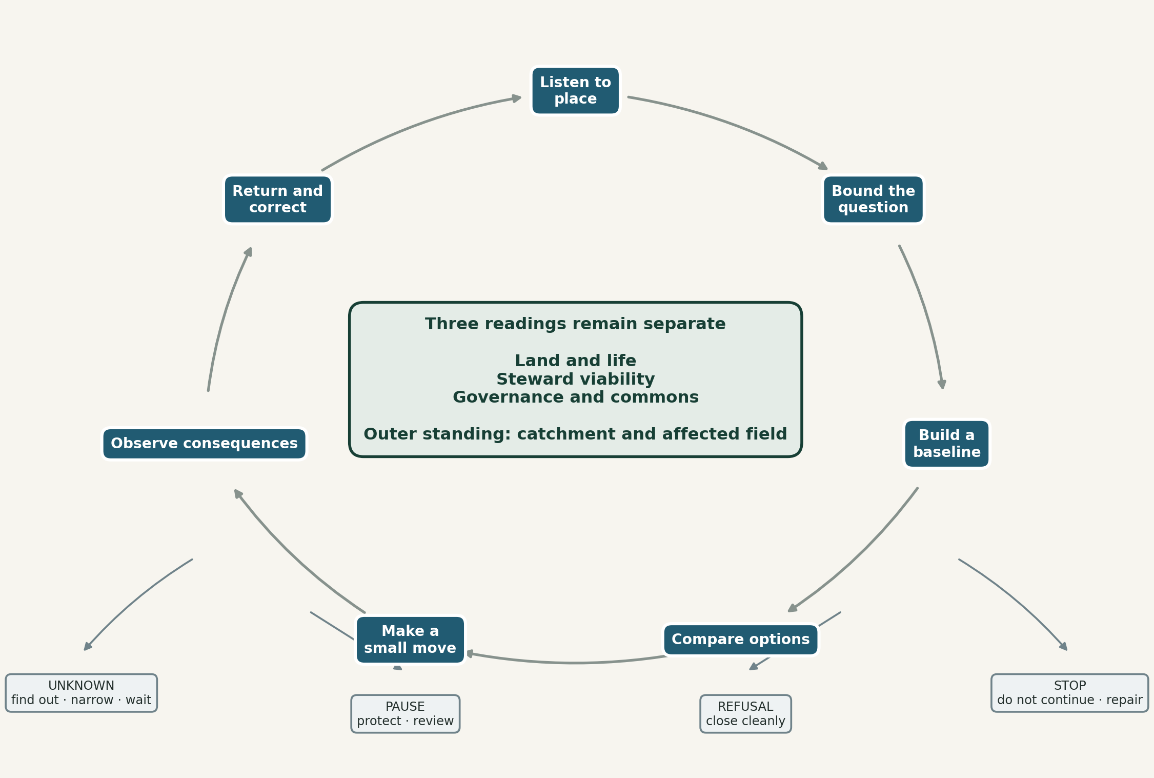
The inquiry is common; its content and outcome are not. A question may travel between fields, while observations, thresholds, authority and action remain situated. Unknown, pause, refusal and stop are legitimate movements, not failures outside the diagram. A Return may reopen the cycle and change the shared grammar.
1 Listen to place Begin with the steward’s account, existing practice, history, pressures, hopes and refusals. Ask what is alive, what is at risk and what must not be misunderstood.
2 Bound the question Name one locally useful question, the place and season it concerns, who has standing, and what falls outside the inquiry.
3 Build a baseline Record only what is needed to make the next decision responsibly. Preserve unknowns and separate current evidence from proposals.
4 Compare options Include maintenance, demand reduction, protection, assisted recovery, technical intervention and doing nothing. Compare burden, cost, reversibility, rights and downstream effects.
5 Make a small move Choose the smallest action that can produce useful learning without exceeding authority, capacity or evidence.
6 Observe consequences Use the three separate readings. Record weather, season, confounders and the limits of attribution.
7 Return and correct Return a useful account locally, revise the record, and continue, adapt, pause or stop. Share outward only within consent and privacy boundaries.
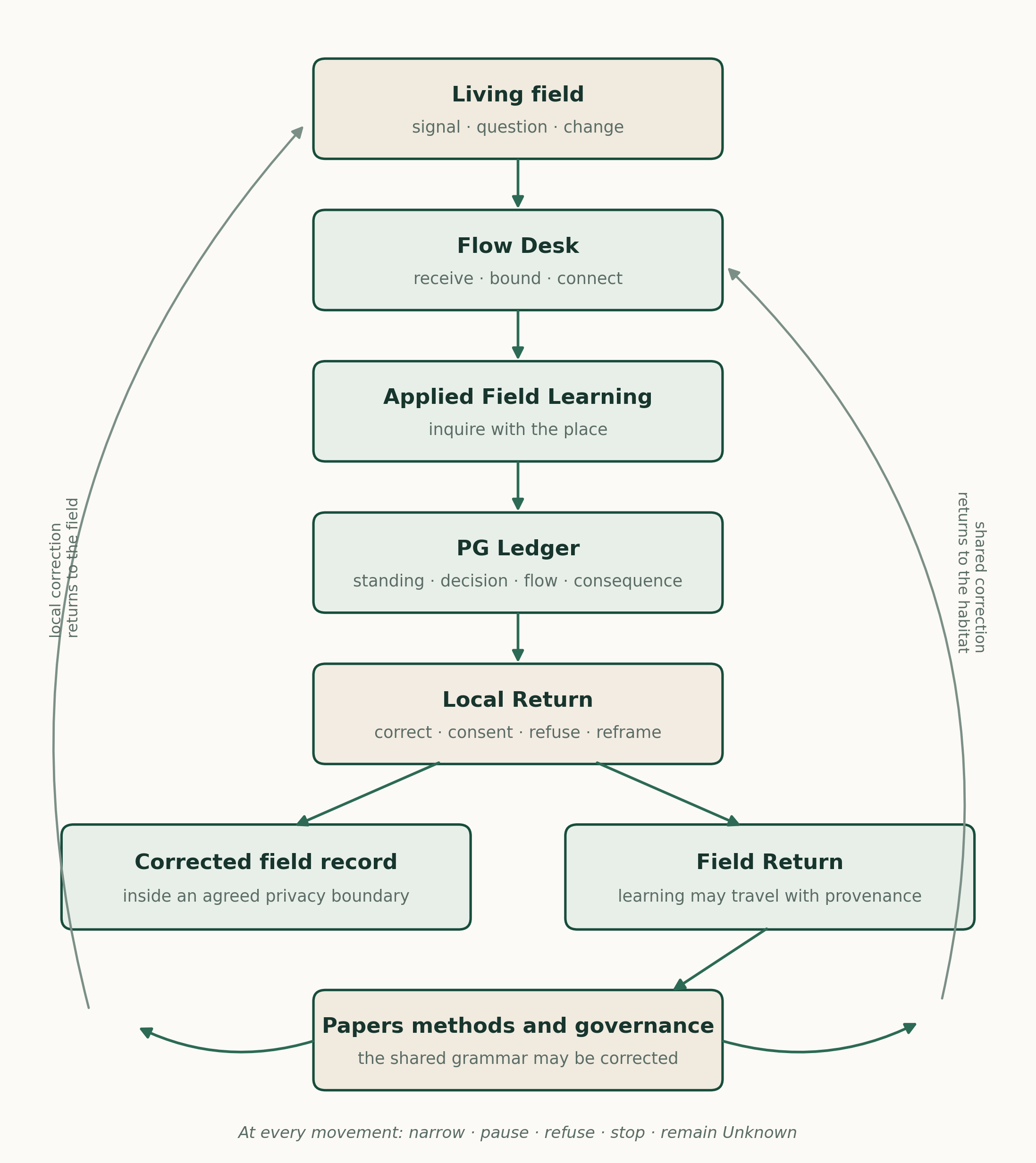
A signal, question or change begins in a living field. Flow Desk receives and bounds it without deciding its meaning in advance. Applied Field Learning supports situated inquiry, while the PG Ledger holds evidential standing, decisions, resource flows and consequences over time. Local Return allows the people and place concerned to correct, consent to, refuse or reframe the record. Only then may an agreed field record support a wider Field Return. What travels may correct not only the next field movement, but also Spiralweb’s papers, methods and governance. This is not a mandatory sequence. Any movement may narrow, pause, return, stop or remain Unknown, and no public record is required where consent or safety does not permit it.
One movement several functions
Flow Desk, Applied Field Learning, the operative formats, PG Ledger, Local Return and Field Return are not competing models. They hold different functions within one movement. Flow Desk holds and routes what arrives. Applied Field Learning shapes the inquiry. The operative formats provide proportionate forms of work. PG Ledger preserves memory and standing. Local Return keeps correction and authority close to the place. Field Return allows learning to travel without transferring that authority.
A common learning cadence
The cadence is not another stage model. It is a small set of questions that can tune different subjects to the same relational discipline while answers remain situated.
| Question | What it protects |
|---|---|
| What is moving? | Names the signal, question, proposal, need or change without deciding its meaning in advance. |
| Where does authority live? | Identifies who may describe, correct, consent, decide, refuse or remain outside. |
| What is actually known? | Keeps Observed, Reported, Agreed, Proposed and Unknown distinct. |
| What may be affected? | Reads Land and Life, Steward Viability, Governance and Commons, and the wider catchment where material. |
| What is the smallest responsible movement? | Chooses action, further inquiry, narrowing, waiting, Return, pause or stop in proportion to consequence. |
| What must return and what may change? | Specifies Local Return, outward sharing and whether the field record, Ledger, method or governance must be corrected. |
Three readings that do not compensate
A field can show ecological promise while exhausting the steward. A steward can remain committed while governance is unclear. Strong governance cannot make unsafe water safe. The three conditions are connected, but a positive reading in one cannot cancel a serious problem in another.
| Reading | What it asks | Examples of evidence |
|---|---|---|
| Land and Life | What is happening to water, soil, habitat, vegetation, animals and ecological function? | Water level and quality, cover, erosion, survival, soil condition, habitat indicators, local ecological observation |
| Steward Viability | Can the people carrying the work continue without hidden depletion? | Time, income, food security, labour, health, care burden, tools, safety, motivation and right to pause |
| Governance and Commons | Are authority, rights, consent, memory, money and correction held legitimately? | Mandate, tenure, consent, decision record, dissent, recipient and payment route, privacy, Return and revision |
The stoplight method
| State | Meaning | Usual implication |
|---|---|---|
| Green | Stable enough for the current bounded work. It is not certification and does not authorise expansion. | Continue within scope and review at the agreed time. |
| Yellow | Strain or emerging instability is present. | Reduce, correct or observe more closely before adding burden. |
| Red | Risk is unacceptable for ordinary continuation or expansion. | Pause, protect and review. Repair or emergency support may still move. |
| Unknown | Evidence or legitimate standing is insufficient. | Find out, narrow the claim or wait. Unknown is not a softer Yellow. |
| No reading in scope | The stream has not yet been read for this decision. | Do not imply a colour. Decide whether a reading is needed. |
| OPERATIONAL RULE Colours never average. A Green and a Red do not make Yellow. The consequence follows the condition that requires protection. |
|---|
Practice families and their limits
The literature supports several promising practice families, but effects are heterogeneous and often depend on climate, starting condition, design and management. The table below therefore treats practices as candidates to investigate, not packages to transfer.
| Practice family | Why it may help | What must remain open |
|---|---|---|
| Protect existing cover and natural regeneration | Avoids disturbance and may use living root systems already adapted to the place. Farmer-managed natural regeneration in Niger has been associated with livelihood and tree-cover benefits. | Requires legitimate tree tenure, protection and locally viable management. Evidence from Niger does not specify outcomes elsewhere. |
| Soil cover organic matter and reduced disturbance | Can reduce erosion and bare-soil evaporation, moderate surface temperature, feed soil organisms and improve aggregation, infiltration or plant-available water under suitable conditions. Biomass retained through litter, compost, mulch or pruning residues can support these processes. | Effects depend on texture, depth, bulk density, residue quality and quantity, rainfall, termites, fire, weeds and labour. Organic matter does not create water, and its direct average effect on available water capacity is modest and variable. Site measurements are needed before converting added topsoil or carbon into litres. |
| Agroforestry and multi-strata systems | Persistent multi-layer cover may add roots, litter, biomass cycling, shade, roughness and microclimatic buffering while supporting crops and habitat. At suitable cover and density, trees can improve infiltration and reduce runoff on degraded dryland soils. | Trees compete as well as facilitate and transpire stored water. Catchment studies show that afforesting grasslands or shrublands can reduce runoff, especially proportionally at dry sites. Species, density, age, prior cover, rooting pattern, pruning, rainfall, soil, irrigation and catchment position matter. “Food forest” is not one tested treatment, and a greener field may still use more blue water. |
| Syntropic agriculture | Offers a practice tradition centred on succession, stratification, dense establishment, selective pruning and on-site biomass cycling. Chop-and-drop can be framed as a testable way to build cover and organic inputs while managing light and competition. | A 2025 Personal View synthesised 67 studies, mainly from tropical systems, and found promising but mixed outcomes alongside high labour and knowledge demands. Evidence remains geographically and climatically concentrated, with limited transfer evidence for water-limited Mediterranean settings. Labour, establishment irrigation, fire, species fit, pruning intensity and water competition require local testing. |
| Earthworks and rainwater harvesting | Contour structures, pits, bunds and small catchments can slow runoff, concentrate water and reduce erosion in some drylands. | Poor siting can cause waterlogging, failure, erosion or conflict downstream. Design needs slope, soil, rainfall intensity, overflow and maintenance knowledge. |
| Efficient irrigation and demand management | Drip, scheduling, mulching, leak repair and crop choice may reduce applied water or increase useful production. | Efficiency does not guarantee aquifer recovery. Saved applied water can be consumed through expansion, changed crops or higher evapotranspiration, while altered return flows can affect other users. Track withdrawal, consumptive use and recoverable return flow where material. Drip irrigation can redistribute salts; water minimisation must not override crop-specific leaching and drainage needs. |
| Storage reuse and treatment | Reservoir repair, rainwater storage, safe reuse and constructed wetlands may buffer variability and improve quality. | Quality, pathogen and salinity risks require testing and maintenance. Storage has evaporation and opportunity costs. Where source, soil or crop indicates salinity risk, assess irrigation-water EC, root-zone ECe, sodium hazard, drainage and leaching need before assuming that less applied water is safer. |
| Groundwater and engineered supply | A well, deeper borehole or conveyed supply may be necessary for survival and continuity. | It can transfer cost and depletion through the aquifer. Permission, hydrogeology, water quality, energy, competing use and long-term yield must be investigated. |
| Managed grazing | Timing, recovery, stocking rate and mobility can support vegetation and livelihoods in suitable rangelands. | Research does not show rotational grazing is universally superior to continuous grazing. Stocking rate, rainfall and adaptive management often dominate outcomes. |
| Ecological restoration | Reference ecosystems, assisted recovery and explicit recovery attributes can support more rigorous restoration practice. | Historical references must be read under climate change and social use. Tree planting can damage native grasslands and does not substitute for protection of intact ecosystems. |
What the external evidence supports
The evidence is strongest at the level of conditional propositions rather than universal recipes. Ostrom’s social-ecological systems framework shows why resource systems, users, governance arrangements and broader settings must be analysed together. Ecological restoration standards emphasise reference models, stakeholder engagement, measurable recovery and adaptive management. Knowledge co-production research emphasises context, plural ways of knowing, shared goals and iterative learning. The Spiralweb architecture does not conflict with these principles. That consistency is a minimum condition, not evidence that the architecture works.
Agroforestry evidence is generally promising but variable. Torralba et al. (2016) found positive average effects on biodiversity and several ecosystem services across European studies, while also finding heterogeneity and trade-offs. Krebs and Bach (2018) map permaculture principles to scientific literature; this supports component-level inquiry, not proof of a complete farming system. A 2024 paired-site study of nine Central European permaculture sites reported higher soil carbon stocks, lower bulk density and higher earthworm and plant diversity than nearby conventional fields (Reiff et al. 2024). The sites were practitioner-selected, had differing histories, and were observational pairs rather than randomised treatments. The study shows that whole-system practice can be investigated; it does not isolate causation or predict Morocco, Uganda or Mexico City.
Dryland recovery also shows that planting is not the only pathway. Farmer-managed natural regeneration in Niger works with existing rootstock and farmer decisions rather than importing a plantation model (Haglund et al. 2011; Tougiani et al. 2009). This is relevant to the inquiry grammar because it begins by asking what regenerative capacity is already present. It does not make FMNR suitable everywhere.
The literature also disciplines enthusiasm. The classic synthesis by Briske et al. (2008) found that rotational grazing was not consistently superior across rangeland experiments; it is a reference point in a continuing adaptive-management debate, not the last word. Tree planting is not a simple substitute for emissions reduction, ecosystem protection or context-specific restoration (Holl and Brancalion 2020). Water saving at plot level can fail to produce basin-level savings when consumption expands or return flows change. These are not reasons for inaction. They are reasons to make boundaries, counterfactuals and total resource use visible.
Current field pixels
The following summaries state the present evidence boundary as of 20 September 2026. They are not needs assessments, local agreements or funding decisions. Each must be returned for local correction before consequential use. This public working version uses roles rather than personal names where publication consent for this paper has not been confirmed.
| Place | Present basis | Land and water inquiry | Claim boundary |
|---|---|---|---|
| Doukkala · Morocco | Preparatory basis for one possible field inquiry across two proposed test fields within a wider holding of approximately 80 hectares. One would introduce a multi-strata agroforestry or food-forest design into a reported state-supported pomegranate planting, with trees approximately six to eight metres apart and dry, sparsely covered interrows. The other would establish a layered field from the beginning with protection and fencing. Both are intended to use drip irrigation. A supplied photograph shows water in one large lined reservoir; the local account reports that it filled completely after the wet winter. A second, smaller reservoir and several wells are also reported. All design and condition details await baseline correction. | Map the whole 80-hectare water field as one system before treating present storage as water security or allocating water to the test fields. Record sources, reservoirs, wells, losses, present and added withdrawal, estimated consumptive use and recoverable return flows where material, competing use and rights. For each test field, record starting cover and bare ground, soil profile, texture, bulk density and organic matter, infiltration, soil moisture at useful depths, surface temperature, existing tree condition, proposed strata and density, biomass inputs, irrigation volume, salinity indicators where relevant, labour and reference conditions. Treat the fields as documented trajectories, not a causal experiment. Until source relations and the affected aquifer are confirmed, affected-field standing is Unknown. | The photograph supports only that the large lined reservoir held water at the time recorded. Reservoir fullness, the second reservoir, wells, plantation origin, spacing, condition and both field designs require dated local confirmation. No activated field cycle, approved grant or agreed observation rhythm exists. Year-one survival is a primary indicator. Six months can show setup and early establishment; three to five years is a Proposed establishment horizon, not evidence of mature function or regenerated hydrology. |
| Firmaty · Had Soualem Morocco | An existing two-hectare peri-urban permaculture practice held by a local steward. The steward has asked Spiralweb to explore support for deepening the existing well. The Green Hub inquiry also asks whether locally suitable water technologies, recharge-supporting measures or combined designs could reduce or remove that need. A cross-field relational holder provides continuity and has recently visited the field; this does not replace the steward’s authority. | The central question is how Spiralweb can help secure the field’s viable water future, including whether it can responsibly support a deeper well. Confirm the water source and aquifer, well condition, levels, yield, quality, energy, present withdrawal, likely consumptive use, return flows, rights and cumulative effect. Where salinity is plausible, include irrigation-water EC, root-zone ECe, sodium hazard, drainage and crop-specific leaching need. Compare rehabilitation or deepening with irrigation, storage, rain capture, safe reuse, runoff and infiltration measures, atmospheric harvesting and combined designs. Treat atmospheric systems as household, nursery or propagation options unless local calculations support more. In parallel, test soil and vegetation hypotheses only where species, density, labour, fire and wider hydrology make them plausible. | The request to deepen the well is Reported and possible support is Proposed. A deeper well is neither approved nor rejected in advance. Because it may increase or shift abstraction, it enters Tier 3 unless evidence removes the trigger. The inquiry may lead to support for an alternative, a combined design or a deeper well. No intervention is yet selected, funded or activated; affected-aquifer standing and the practical performance of candidate technologies remain Unknown. |
| Kitgum Uganda | A locally held relationship in drought response and readiness. A July 2026 report records crop loss, community activity, nursery preparation and a borehole as a readiness anchor. One Dashboard reading recorded Land and Life Red, Steward Viability Yellow and Governance and Commons Green. | Borehole condition, yield, access and sustainable nursery capacity remain unknown. Planting depends on sustained rain, water access, protection, capacity and a local decision, not a forecast or first shower. | One completed format is early use, not a regular Ledger. Public collection authorisation does not itself create funds. The current baseline explicitly says no field funds were available at its date. |
| Xochimilco · Mexico City | A centuries-old wetland agricultural landscape with chinampa practice, conservation work, public institutions, producers, markets, conflict and mature knowledge. Research on the chinampa-refuge model shows the value of connecting agroecological production, habitat recovery and producer participation. | Water quality, subsidence, treated wastewater, invasive species, urban pressure, livelihood and governance interact. Spiralweb’s possible role is a locally authorised learning relation inside a full field, not the introduction of a regenerative model. | A working invitation exists. There is no university commitment, selected site, local project agreement, funding decision or active Ledger rhythm. No movement occurs until a locally authorised group and question, and Spiralweb’s distinct contribution, are identified. |
Morocco as a water governance inquiry
Morocco’s recent winter rain brought important relief after a prolonged drought, but rainfall recovery does not remove structural water risk. National and basin evidence points to increasing scarcity, groundwater pressure, agricultural demand and the need to connect infrastructure with demand management and governance. FAO’s work on the Berrechid aquifer is especially relevant because it treats metering, user organisation and aquifer contracts as governance questions rather than only engineering questions. The World Bank’s Morocco climate and development work likewise frames water as a central adaptation and development constraint.
For the Berrechid aquifer, FAO reports that the annual water-balance deficit rose from about 20 million cubic metres in 2010 to about 30 million in 2016, and describes aquifer contracts, user associations and metering as parts of the response. A 2023 study of 22 groundwater samples found strong spatial variation: about 40.9 per cent were classified as excellent, 45.5 per cent as poor, 4.5 per cent as very poor and 9.1 per cent as unsuitable for human consumption (Moukhliss et al. 2023). That heterogeneity strengthens the location gate. Province-level findings do not automatically describe Had Soualem or any particular well; they become field evidence only after exact location, aquifer connection, water source and current use are confirmed.
Two Moroccan inquiries
The two Moroccan relationships share a water discipline but not the same decision. Doukkala begins with a system-mapping problem. Firmaty begins with a consequential infrastructure question. Treating them as the same kind of case would either overburden the first or under-investigate the second.
In Doukkala, the first task is to map the water field across the approximately 80-hectare holding: several wells, one large lined reservoir reported as full after the wet winter, a second smaller reservoir, existing uses and the two proposed drip-irrigated test fields. The map must show how water is sourced, stored, pumped, conveyed, lost and allocated before the test fields are treated as bounded additions. A wet winter creates present capacity; it does not by itself establish recharge, sustainable yield or future security.
The two Doukkala test fields ask one ecological question through different starting conditions. In the first, a proposed multi-strata agroforestry or food-forest design would be established within a reported state-supported pomegranate planting whose trees stand roughly six to eight metres apart, with dry, sparsely covered ground between them and limited vigour reported locally. In the second, a layered dryland agroforestry field would be designed from the beginning, including protection and fencing. Both are proposals awaiting baseline correction. They can become two documented trajectories with useful reference conditions. They are not a replicated experiment and cannot isolate the effect of one practice. Comparisons should match soil texture, slope, prior management and water supply as far as feasible and state what remains different.
The planning horizon must match living establishment. In the first year, survival is the decisive ecological indicator alongside water use, labour and reasons for loss. A six-month cycle can document preparation, planting, irrigation and early survival; it cannot demonstrate a functioning food forest or long-term water regeneration. Three to five years is a working horizon for establishment, not mature ecosystem function or regenerated hydrology. The hypothesis would be weakened if cover and biomass rise only through increasing irrigation, if soil moisture or infiltration does not improve relative to a useful reference, if water demand or labour becomes unviable, or if effects outside the test field are negative.
In Firmaty, the steward’s request to deepen an existing well brings the architecture into a real test. The field may need more reliable water to remain alive, while a deeper well may increase abstraction, reach another water-bearing layer, change quality or cost, or shift effects beyond the field. The inquiry begins with commitment to the steward and the existing permaculture practice. It does not presume that deepening is wrong, or that an alternative technology will be sufficient. Spiralweb is not deciding whether people in dry regions may use groundwater. It is deciding what it can responsibly help make possible in this particular relationship.
The Green Hub inquiry should therefore compare a locally realistic water portfolio: well rehabilitation or deepening; pumping and irrigation changes; storage and rainwater capture; safe reuse; runoff spreading and infiltration where lawful and hydrogeologically appropriate; soil-water retention, shade and crop or area adjustment; and atmospheric water harvesting. Fog collectors, radiative dew surfaces, active condensation and sorbent systems remain candidates only. Without a local yield, area, energy, water-quality, maintenance and cost calculation, they should be treated as possible household, nursery or propagation supplies rather than whole-field irrigation. Morocco’s fog-harvesting work in the Anti-Atlas shows that atmospheric capture can work in a suitable place; it does not establish suitability at Had Soualem (Fondation Dar Si Hmad, current project description). If a credible combination can reduce or remove the need to deepen the well, Spiralweb may help test it if resources become available. If not, a deeper well remains within the option set and may also be considered under lawful, technically credible and locally agreed conditions. Unknown keeps the comparison open; it is not a concealed refusal.
Firmaty also tests scale. A two-hectare green patch may hold soil, shade, habitat and practical knowledge while remaining dependent on a wider and declining water field. The inquiry should ask both how the existing practice can survive and whether its vegetation, soil cover, biomass cycles and water design reduce demand or improve the site’s capacity to hold water. More canopy, a food-forest layer or syntropic pruning is not presumed to be the answer. Each is a locally adapted design hypothesis to compare with water source, labour, maintenance, fire, species fit and the surrounding hydrology. If the field continues to dry despite responsible support, documenting that trajectory is also a valid Return.
The Spiralweb fields should not be used to make basin claims they cannot support. They can become small, well-documented pixels: how a reservoir is used after a wet winter; what a two-hectare field requires to remain viable; what changes when soil cover, irrigation, crop choice, storage or abstraction changes; and how the costs and benefits are distributed. The pixel is useful when it is both humble and precise.
Worked example: a bounded Doukkala inquiry
| STANDING Illustrative inquiry only. This is not a current field record, an agreed action or a funded decision. Every line must be returned and corrected locally before use. |
|---|
| Movement | Illustrative content | Evidence standing |
|---|---|---|
| Listen | A local steward reports that the large lined reservoir filled completely after the wet winter. A supplied photograph shows water in that reservoir. A second smaller reservoir, several wells and two intended drip-irrigated test fields are also reported. | Observed for the photograph: a large lined reservoir holding water, with date and location metadata still required. Reported: full condition after the wet winter, the second reservoir, several wells and intended irrigation. |
| Bound | Possible question: how does water move through the approximately 80-hectare holding, and how can two bounded test fields be supplied by drip irrigation without concealing additional abstraction, losses or competing use? | Proposed. The system boundary, test-field areas, source relations, season and decision holders are not yet agreed. |
| Baseline | Map all wells, reservoirs, pumps, pipes, elevations, irrigated areas and users; record storage, refill, losses, well performance, rights, present and added withdrawal, estimated consumptive use and recoverable return flows where material. In each starting area, record cover and bare ground, pomegranate or other woody vegetation, soil profile and texture, bulk density and organic matter, infiltration, soil moisture, surface temperature, proposed planting density, biomass inputs, salinity indicators where relevant and useful reference conditions. | Mostly Unknown. The photograph and local account establish a starting record, not a verified whole-farm water balance. |
| Compare | Follow two bounded designs from different starting conditions: a multi-strata retrofit within the existing pomegranate field, and a protected layered field established from the beginning. Within each, compare feasible combinations of soil cover, biomass cycling, irrigation scheduling, species and density; also retain the options to narrow, delay or not plant. Match reference conditions where feasible, but do not present the two fields as a controlled or replicated experiment. Compare water, labour, cost, first-year survival, reversibility and affected-field consequence. | Candidate designs and comparisons, not recommendations. The establishment horizon and indicators remain to be agreed. |
| Small move | A candidate low-burden step is a steward-checked water asset and flow map, followed by proportional measurements of the two reservoirs, wells and intended test fields before planting or pumping changes are agreed. | Proposed; requires steward agreement, a responsible holder and a resourced Return. |
| Observe | Keep Land and Life, Steward Viability and Governance and Commons separate; also read the affected aquifer and downstream field. | Method proposed; no status assigned. |
| Return | One locally useful page in an agreed language, with source, unknowns, correction route, responsible author, budget and due date. | Required before the synthesis is treated as current. |
Xochimilco as a full field
Xochimilco demonstrates why local practice must not be treated as an empty recipient. The landscape joins food production, canals, habitat, cultural heritage, water management, markets, urban development and public authority. The chinampa-refuge model is particularly instructive because it links producer practice with canal filters and habitat refuges while keeping the social-ecological transformation visible (Eakin et al. 2019; Figueroa et al. 2022). Spiralweb can learn from this composition. It should not claim it as its own or reduce it to a demonstration site.
Water beyond administrative boundaries
Water moves across properties, municipalities, states, countries and epistemic categories. Healthy Roots contributes a conceptual language of capacity, contact, water and stewardship economy to this paper. It does not evidence an active Spiralweb field relationship. Its role here is lineage: a reminder that water may connect micro, meso and macro fields while authority remains situated.
Some legal systems have created explicit standing for water bodies and their catchments. Spain’s 2022 Mar Menor law recognises the lagoon and its basin as a legal subject represented through public, citizen and scientific bodies. Colombia’s Constitutional Court recognised the Atrato River as a subject of rights with guardianship arrangements. New Zealand’s Te Awa Tupua Act recognises the Whanganui River as a legal person. These are distinct legal and cultural arrangements, not a template and not authority for Spiralweb to speak for water. They show that governance can make the living water field and absent interests institutionally present.
From pixels to bioregional learning
A network becomes useful when difference is preserved well enough for patterns to be examined. Standardisation by fixed outcomes would erase the very conditions that matter. Total uniqueness would prevent shared learning. Spiralweb’s middle path is a common record structure with local questions, categories and thresholds.
Across fields, the network may ask questions such as:
Which forms of cover or vegetation persist through dry periods, and at what water cost?
When does improved irrigation reduce total demand, and when does it enable expansion?
Which maintenance burdens fall on the steward, women, households or unpaid community labour?
How do locally meaningful signs relate to instrument readings and institutional records?
What conditions make a small action reversible, governable and worth continuing?
Which questions recur across climate zones even when the answers differ?
Aggregation should therefore report patterns and exceptions, not manufacture a global score. A regional synthesis might say that water quality is repeatedly unknown, that steward labour is undercounted, or that storage is a shared constraint. It should not imply that one colour, indicator or intervention has the same meaning everywhere.
The PG Ledger and Flow Desk
The PG Ledger is the memory of the inquiry. Flow Desk is the relational operating surface that receives signals, distinguishes standing, routes attention, protects boundaries, remembers commitments and returns decisions. Together they can connect field consequence with money and governance without turning the field into a donor reporting object.
When it is a Ledger
A record becomes an active PG Ledger only when all of the following are present:
a bounded purpose and named holder;
legitimate authority, consent and privacy boundaries;
dated observations and decisions with evidence standing;
the three separate readings where relevant;
a visible connection between resource flows and purpose;
a locally useful Return;
an agreed rhythm or event trigger;
and evidence that the record can correct a later decision.
A collection of forms is not yet a Ledger. A public page is not yet a Ledger. A financial transaction list is not yet a Ledger. The defining feature is correctable continuity: later action can be traced to earlier observation, authority, decision, resource flow and consequence.
The five operative formats
| Format | Operational use |
|---|---|
| Steward Review Dashboard | A review point across the three separate conditions, with reasons, uncertainty, dissent, next movement and Return. |
| Observation Sheet | A dated observation or question with method, local knowledge, interpretation, hypothesis, sources and unknowns. |
| Bounded Action Sheet | Purpose, authority, consent, affected life, holders, reversibility, stop conditions and review. |
| Governance and Decision Log | Mandate, reasons, evidence, uncertainty, alternatives, dissent and route to revision. |
| Financial Ledger | Source, recipient, amount, classification, purpose, evidence, privacy, stream and later Return, alongside formal accounting. |
The formats are not five stages, five duties or a compulsory chain. A field uses the smallest format that the decision and consequence justify. The rule is proportionality: no more legibility than consequence justifies, and no less accountability than consequence requires.
Proportional evidence and its budget
Evidence work is work. Measurement, translation, local participation, documentation and Return must be named and resourced rather than transferred silently to the steward. The Steward’s Journey governs invitation, support, pause, roles and dignity; the PG Ledger governs evidence, provenance, decision, consequence and correction. Financial design must connect the two.
| Tier | Decision profile | Proportionate requirement |
|---|---|---|
| 1 · Light | Small, reversible action with limited shared-water consequence. | Local observation; legitimate authority; basic safety; one or two indicators; a stop condition; short Return. |
| 2 · Moderate | Material cost, added demand, contested standing or effects that need comparison. | Tier 1 plus relevant water or soil tests; options and counterfactual; burden and cost; reference point; specialist input where needed. |
| 3 · High | Any Tier 3 entry gate, including a new or deeper well, material change in withdrawal, consumptive use or return flows, material shared-water effect, contamination risk, major earthworks, hard-to-reverse action or consequential public claim. | Permit and rights; hydrogeology or equivalent specialist assessment; water quality; basin/catchment and downstream effect; climate horizon; financed monitoring, translation and Return. |
Tier 3 entry gates
A proposal enters Tier 3 when any one of the following conditions is present. The tier may later be reduced only through documented evidence that removes the triggering condition; urgency, attention or available funding does not lower it.
a new well, deeper borehole, increased pumping capacity, material increase in withdrawal, or material change in consumptive use, evapotranspiration or recoverable return flows;
a plausible material effect on shared or hydraulically connected water, downstream users, wetlands, estuaries, future users or other life;
a contamination, salinity or public-health pathway whose consequence could be serious;
major or hard-to-reverse earthworks, drainage change, ecosystem conversion or infrastructure;
unresolved permits, tenure, water rights, consent, contested standing or a material conflict of interest;
a material financial commitment or public outcome claim that depends on an ecological or hydrological effect not yet established.
Area alone does not determine the tier. Mapping reservoirs and wells across an 80-hectare holding can begin as a bounded observation task. Deepening a well on a two-hectare field may require Tier 3 evidence because consequence, connectivity and reversibility—not plot size—set the burden. If Spiralweb cannot resource the evidence its own decision requires, the answer is to narrow or pause the decision, not to make the steward carry unpaid institutional work.
Return as a delivery obligation
A public synthesis is not a Return. Before a field summary is treated as current, the Return must have an agreed recipient, form, language, author or translator, privacy boundary, budget, due date or event trigger, and correction route. One locally useful page may be enough; 6,000 words of English synthesis usually are not.
| Return field | Question |
|---|---|
| Holder | Who receives, owns and may correct the account? |
| Form and language | What can actually be read and used locally—conversation, one page, audio, French, Arabic, another language? |
| Responsible person | Who prepares, translates and checks it? |
| Boundary | What remains private or requires renewed consent before outward sharing? |
| Resources | Which budget pays for time, translation, data and access? |
| Timing | What date or field event triggers delivery and review? |
| Correction | How is disagreement recorded and the public or internal record changed? |
Money as part of the field
Money changes tempo, authority, expectations and labour. It is therefore not an external administrative layer. The Financial Ledger should connect formal accounts to a locally useful account of purpose and consequence while protecting sensitive personal and banking data. Expenditure in Land and Ecology does not prove ecological improvement. Payment to a steward does not prove viability. Coordination expenditure does not prove legitimate governance. Each claim needs its own evidence.
Applying the Ledger to the association itself can create a public window into how support entered, what purpose governed it, where it moved, what field decision followed, and what remained unresolved. Over time this can test whether Spiralweb practises its own commitments. It can also reveal whether the surrounding world finds the work relevant and whether the association can carry relationships without converting them into promises. This is a proposition to be tested through use, not a claim of achieved transparency.
A responsible field budget therefore separates at least three kinds of support: stable stewardship capacity; concrete field functions, materials and repair; and coordination, evidence, translation, documentation and learning. Formal accounting remains necessary. The Ledger adds the question of what the flow made possible, whom it burdened, and what later evidence changed the account.
The role of AI and the workbench
AI can help search, translate, compare documents, detect contradictions, draft alternative framings, organise evidence and maintain provenance. It can make a small association more capable of holding a complex corpus. It can also amplify error, flatten context, invent continuity, reproduce bias and create a false impression of settled knowledge.
The Spiralweb AI workbench should therefore remain bounded by five rules.
AI may support attention and memory. It may not confer local authority or consent.
Every consequential field claim must retain a human and source route that can be checked.
Sensitive knowledge is minimised and protected; refusal to digitise is a legitimate outcome.
AI-generated synthesis is labelled as synthesis and kept distinct from local testimony and measured evidence.
No funding, stoplight or activation decision is automated. Human holders remain accountable.
Used this way, the workbench is connective tissue rather than command. Its value is not that it knows the field. Its value is that it can help the people with standing see what has been said, what conflicts, what is missing and what requires a Return.
Minimum responsible baseline
A baseline should be light enough to use and strong enough to carry the next decision. The following is a minimum set, not a universal form. Items may be combined, translated or left out with a reason.
| Baseline element | Minimum content |
|---|---|
| Purpose and question | What locally useful question is being investigated? What is outside scope? |
| Place time and history | Boundary, season, prior conditions, recent shocks, relevant long memory and the climate range over the life of the decision. |
| Holders and standing | Steward, affected people, land and water rights, public authority, consent and privacy. |
| Land and life | Water source, timing, quality, withdrawal, consumptive use and return flow where material; soil, cover, vegetation, habitat, animals and contamination. Where salinity risk is plausible, include irrigation-water EC, root-zone ECe, sodium hazard, drainage and crop-specific leaching need. Use local observations for field correction and basin or specialist evidence for processes the field cannot resolve. |
| Steward viability | Time, income, food security, labour, care burden, tools, health, safety and ability to pause. Ask how water-carrying, irrigation and care work are distributed by gender, age and position; do not assume. |
| Governance and commons | Decision route, dissent, tenure, recipient, payment control, maintenance responsibility and public claim boundary. |
| Existing assets and practices | What already works, who maintains it, and what should not be displaced. |
| Options and counterfactual | Protection, maintenance, demand reduction, practice change, technical options and doing nothing. |
| Risk and reversibility | Affected life, downstream effects, stop conditions, failure modes and repair route. |
| Evidence standing | Observed, reported, agreed, proposed and unknown; source and method. |
| Resource flows | Expected and actual money, materials, labour, knowledge and time. |
| Evidence and Return budget | Who pays for participation, measurement, specialist work, translation, documentation and local correction? |
| Return and next review | Who receives the Return, in what language and form, and what event or date opens review? |
Measurement without metric capture
Indicators should be chosen because they can correct a decision, not because they are easy to count or attractive to a funder. A small field may begin with three indicators. A borehole decision may require specialist tests and permits. A wetland collaboration may need ecological, livelihood and institutional measures. The test is practical: what observation would change what we do next?
Some conditions should remain qualitative or private. Cultural meaning, conflict, bodily experience and sacred or protected knowledge are not improved merely by being quantified. The Ledger can record that a protected domain affected a decision without collecting its contents.
The baseline also distinguishes what is required to act safely from what would be useful to learn. Safety, authority, rights and stop conditions may be gates. Additional observations may improve learning without becoming permission slips for every small movement.
Research agenda
The present corpus is conceptually rich and contains increasingly precise field records. It is not yet a complete evidence system. The following work would materially strengthen this paper and the field architecture.
| Priority | Needed work |
|---|---|
| Field correction | Prepare a resourced, locally usable one-page Return for each field. Record language, responsible person, due date, corrections, refusals, preferred local terms, privacy boundaries and consent to any personal naming or outward field detail. |
| Morocco hydrology | Confirm coordinates, basin and aquifer before local aquifer claims; obtain proportionate well and reservoir data; test water quality where material; estimate current and proposed demand; identify permits and competing uses. |
| Firmaty options | Treat the request to deepen the existing well as a Tier 3 Green Hub inquiry, not as an approved or rejected intervention. Confirm the field’s exact location and aquifer connection; the well’s construction, depth, levels, yield, quality, energy, operating cost, permit or right, present withdrawal, likely consumptive use and return flows; neighbouring and cumulative use; and the steward’s viability threshold. Where salinity is plausible, assess water EC, root-zone ECe, sodium hazard, drainage and leaching need. Build a locally costed options portfolio covering rehabilitation or deepening, irrigation and pumping changes, storage and rain capture, safe reuse, runoff capture and infiltration, soil-water retention, crop or area adjustment, atmospheric water harvesting and combined designs. Treat atmospheric systems as household, nursery or propagation options unless local yield and energy calculations support more. Record what Spiralweb could consider if resources become available, what remains Unknown, and how the decision is returned locally. |
| Doukkala baseline | Create a steward-checked map of the approximately 80-hectare water field: all wells, both reservoirs, pumps, pipes, elevations, irrigated areas and competing users. Record storage, refill, losses, well performance, rights, present and added withdrawal, likely consumptive use and recoverable return flows where material. Confirm the reported pomegranate planting, spacing, condition and origin; the second field’s proposed design, protection and fencing; tenure and labour; and species, strata, density and earthworks. Establish useful reference conditions and a three-to-five-year establishment frame covering cover and bare ground, soil profile, texture, bulk density, organic matter, infiltration, moisture, surface temperature, biomass inputs, irrigation volume, salinity where relevant, first-year survival, later growth, labour and cost. State that the two trajectories do not establish isolated causality or mature hydrological regeneration. |
| Kitgum water readiness | Document borehole function, access, yield, nursery distance, protection, household competition and locally defined rain and planting gates. |
| Xochimilco gate | Do not move until one locally authorised question and partner group exist and Arturo and local actors can state what Spiralweb adds without duplicating producer, UNAM or public work. |
| Practice evidence | Commission targeted reviews for dryland agroforestry, water harvesting, groundwater governance, peri-urban permaculture and social-ecological monitoring in the relevant climate zones. |
| Syntropic evidence | Separate claims about the named method from evidence about its components. Document local designs and testable hypotheses without brand-based inference. |
| Ledger validation | Define what would count as usability, burden, correction and trust. Evaluate the five formats through actual cycles rather than internal coherence alone. |
| Association self application | Publish a bounded first Flow view only after formal accounts, purposes, privacy, board decisions and Returns can be connected accurately. |
| Comparative synthesis | After several Returns, examine recurrent questions, differences, surprises and failed assumptions. Do not rank fields by colour or create a composite regeneration score. |
| Governance procedure | Test and formally locate the interim pause and refusal route: mandate, evidence threshold, provisional hold, Board or delegated decision holder, conflict and recusal, Decision Log, Local Return, correction and reconsideration. Record where practice changes the procedure. |
What can be stated now
Spiralweb has a coherent candidate architecture for place-based inquiry, non-compensatory review, resource traceability and correction.
The architecture does not conflict with several established principles in social-ecological systems, knowledge co-production, adaptive management and restoration standards. This is a minimum condition, not evidence that it works.
The field materials show real relationships and increasingly bounded questions, but not a mature cross-field Ledger cadence.
The common land and water paper can guide preparation now, provided it remains visibly correctable and does not outrun local agreement.
What cannot yet be stated
That the interim pause, refusal and reconsideration route is field validated, formally delegated in every case or proven robust under pressure.
That Spiralweb interventions have produced regenerative outcomes across fields.
That the PG Ledger is field validated or low burden in sustained practice.
That any one practice family is the preferred solution across the network.
That current proposals, public horizons or budgets are funded or activated.
That local pixels support basin, national or planetary causal claims without additional evidence.
That the association’s current refusals prove integrity under future pressure from money, urgency or reputation.
What would weaken the framework
The framework should be revised or rejected where practice shows that:
a named technique can safely be treated as regenerative by definition;
one composite score can replace the three readings without hiding decisive harm;
Unknown can be treated as Yellow without increasing risk;
Returns do not correct later decisions or are not useful to field holders;
stewards repeatedly carry uncompensated evidence and translation work;
local Green readings routinely conceal wider-field Red effects;
refusal becomes impossible, arbitrary or practically unreviewable when funding, urgency, loyalty or attention arrives; or
the Ledger records activity and money but not cost, consequence and correction.
Conclusion
Spiralweb does not need a universal regenerative recipe. It needs a shared discipline strong enough to connect places without taking them over. Land and water provide a demanding test because their relations are physical, cultural, political and economic at once. A field can be alive and still fragile. A steward can be capable and still unable to carry unpaid burden. A visible green intervention can still deepen extraction. A pause can be the most regenerative act available.
The proposed architecture begins with contact and ends with correction. It asks what is already alive, what the place and its holders wish to protect, what evidence the next decision requires, and what the smallest responsible movement might teach. It keeps ecological condition, steward viability and governance separate enough to prevent compensation and connected enough to understand consequence. It records money without allowing money to define success. It uses AI to support memory without granting it authority.
If these disciplines become a living monthly and event-based practice, pixels may begin to form a wider intelligence: not a central view that claims to know every place, but a network in which grounded differences can warn, teach and correct one another. That is the paper’s main wager. Its truth will not be settled by the paper. It will be settled, slowly, by use.
At v0.4.1, part of the paper’s credibility still rests on what it refuses to claim. Such refusals are necessary and also cheap before consequential action. The harder test begins when money, urgency, loyalty or reputation presses toward a decision and the Ledger shows what Spiralweb chose, who held authority, who recused, who carried the burden, what it cost, what was refused, how the decision was returned and what had to be corrected.
Source and evidence map
| Source layer | Use | Limit |
|---|---|---|
| Spiralweb current corpus | Definitions, ontology, epistemology, method, stoplight, formats and current public field status. | Primary source for Spiralweb’s own claims; not independent validation. |
| Current field records | Locally reported conditions, proposals, budgets, readiness questions and status boundaries. | Uneven maturity. Must retain date, author, standing and local correction route. |
| Historical design documents | Earlier ambitions, candidate practices and terminology. | Used for provenance and research leads only; not current agreement or status. |
| Peer-reviewed research | Conditional findings on social-ecological systems, co-production, agroforestry, permaculture, grazing, FMNR, restoration and Xochimilco. | Transfer limited by study design, geography and context. No source validates the whole architecture. |
| Institutional sources | Climate, water governance, heritage and restoration context from FAO, World Bank, UNESCO, IPCC, UNCCD and SER. | Useful at national, basin or standards level; does not replace local evidence. |
| This synthesis | A proposed common frame, definitions, inquiry loop, baseline and research agenda. | Authored synthesis for correction. New formulations are propositions, not findings about field outcomes. |
References
Briske, D. D. et al. 2008. Rotational grazing on rangelands: reconciliation of perception and experimental evidence. Rangeland Ecology & Management 61: 3–17. DOI 10.2111/06-159R.1. Open source
Eakin, H. et al. 2019. Social-ecological transformation in urban landscapes and the Shifting Mosaic of Xochimilco. Ecology and Society 24(3): 15. DOI 10.5751/ES-11030-240315. Open source
FAO. Enhancing management of water resources in the Berrechid aquifer in Morocco through the implementation of contracts. Open source
FAO. 2021. The State of the World’s Land and Water Resources for Food and Agriculture Systems at breaking point. Open source
Figueroa, F. et al. 2022. Integrating agroecological food production ecological restoration and ecosystem services in the chinampa refuge model. Sustainability 14 9641. DOI 10.3390/su14159641. Open source
Gann, G. D. et al. 2019. International principles and standards for the practice of ecological restoration Second edition. Restoration Ecology 27 S1 S1–S46. DOI 10.1111/rec.13035. Open source
Gann, G. D. et al. 2026. International principles and standards for the practice of ecological restoration: Third edition. Restoration Ecology 34(S2): e70441. DOI 10.1111/rec.70441. Open source
Haglund, E. et al. 2011. Dryland tree management for improved household livelihoods: farmer-managed natural regeneration in Niger. Journal of Environmental Management 92: 1696–1705. DOI 10.1016/j.jenvman.2011.01.027. Open source
Holl, K. D. and Brancalion, P. H. S. 2020. Tree planting is not a simple solution. Science 368 580–581. DOI 10.1126/science.aba8232. Open source
IPCC. 2022. Climate Change 2022 Impacts Adaptation and Vulnerability Working Group II contribution to the Sixth Assessment Report. Open source
Krebs, J. and Bach, S. 2018. Permaculture Scientific evidence of principles for the agroecological design of farming systems. Sustainability 10 3218. DOI 10.3390/su10093218. Open source
Moukhliss, H. et al. 2023. Assessment of groundwater quality in the Berrechid aquifer using water quality index and statistical methods, Morocco. Ecological Engineering & Environmental Technology 24(4): 187–199. DOI 10.12912/27197050/159969. Open source
Norström, A. V. et al. 2020. Principles for knowledge co-production in sustainability research. Nature Sustainability 3: 182–190. DOI 10.1038/s41893-019-0448-2. Open source
Ostrom, E. 2009. A general framework for analyzing sustainability of social-ecological systems. Science 325: 419–422. DOI 10.1126/science.1172133. Open source
Reiff, J. et al. 2024. Permaculture enhances carbon stocks soil quality and biodiversity in Central Europe. Communications Earth and Environment 5 305. DOI 10.1038/s43247-024-01405-8. Open source
Tengö, M. et al. 2014. Connecting diverse knowledge systems for enhanced ecosystem governance The multiple evidence base approach. Ambio 43 579–591. DOI 10.1007/s13280-014-0501-3. Open source
Torralba, M. et al. 2016. Do European agroforestry systems enhance biodiversity and ecosystem services? A meta-analysis. Agriculture, Ecosystems & Environment 230: 150–161. DOI 10.1016/j.agee.2016.06.002. Open source
Tougiani, A., Guero, C. and Rinaudo, T. 2009. Community mobilisation for improved livelihoods through tree crop management in Niger. GeoJournal 74 377–389. DOI 10.1007/s10708-008-9228-7. Open source
UNCCD. 2022. Global Land Outlook Second edition Land restoration for recovery and resilience. Open source
UNESCO World Heritage Centre. Historic Centre of Mexico City and Xochimilco. Open source
World Bank. 2022. Morocco Country Climate and Development Report. Open source
Spain. Ley 19/2022, de 30 de septiembre, para el reconocimiento de personalidad jurídica a la laguna del Mar Menor y su cuenca. Open source
Constitutional Court of Colombia. 2016. Judgment T-622/16: Atrato River and biocultural rights. Open source
New Zealand. Te Awa Tupua (Whanganui River Claims Settlement) Act 2017. Open source
Ilstedt, U., Bargués Tobella, A., Bazié, H. R. et al. (2016). Intermediate tree cover can maximize groundwater recharge in the seasonally dry tropics. Scientific Reports, 6, 21930. Open source
Minasny, B. and McBratney, A. B. (2018). Limited effect of organic matter on soil available water capacity. European Journal of Soil Science, 69(1), 39–47. Open source
Fondation Dar Si Hmad. TAGUT fog collection project, Southwest Morocco. Open source
Farley, K. A., Jobbágy, E. G. and Jackson, R. B. (2005). Effects of afforestation on water yield: a global synthesis with implications for policy. Global Change Biology, 11(10), 1565–1576. Open source
Grafton, R. Q., Williams, J., Perry, C. J. et al. (2018). The paradox of irrigation efficiency. Science, 361(6404), 748–750. Open source
Ayers, R. S. and Westcot, D. W. (1985). Water quality for agriculture. FAO Irrigation and Drainage Paper 29 Rev. 1. Open source
Jacobi, J., Andres, C., Assaad, F. F. et al. (2025). Syntropic farming systems for reconciling productivity, ecosystem functions, and restoration. The Lancet Planetary Health, 9(4), e314–e325. Open source
Spiralweb. PG Ledger current public page reviewed 20 September 2026. Open source
Spiralweb Papers. Knowing from the Ground current public paper reviewed 20 September 2026. Open source
Spiralweb Papers. The Living Field current public paper reviewed 20 September 2026. Open source
Spiralweb Papers. Living Landscapes current public paper reviewed 20 September 2026. Open source
Spiralweb Papers. The Spiral of Hypotheses current public paper reviewed 20 September 2026. Open source
Spiralweb Papers. At holde jorden levende. Field Paper, public pre-study v0.11, 8 September 2026. Open source
Spiralweb Stewardship Association. Healthy Roots 15 June 2026. Internal working paper in the Spiralweb Library.
Spiralweb Stewardship Association. Conscious Co-Created Food Systems: A Field Protocol, version 1.0, April 2026. Internal working protocol.
Spiralweb Stewardship Association. Flow Desk Architecture version 0.2. Internal working architecture.
Spiralweb Stewardship Association. Doukkala operational proposal response budget and readiness documents September 2026. Current working field records.
Spiralweb Stewardship Association. Kitgum August 2026 Relationship Readiness and Support Baseline candidate version 0.1 dated 21 August 2026.
Spiralweb Stewardship Association. Xochimilco and Regenerative City working proposal and Roadmap for Arturo versions 0.2 to 0.4 July to September 2026.
Editorial and status note
This is a working field synthesis and framework, not a systematic review, a field agreement or a final protocol. Field status is dated 20 September 2026 and should be refreshed when local corrections, agreements, evidence or funding status change. Scientific references were selected to test the main propositions and limits, not to claim comprehensive coverage. Before programme design or consequential funding decisions, relevant claims require a documented search method, specialist review where needed, and field-reviewed Returns.
Back to top ↑Spiralweb Stewardship Association · Applied Field Learning. Published through Spiralweb Papers under human responsibility and open to correction. Publication activates no field relationship, funding flow or protocol.